


คำอธิบายของ Mapit GIS - Map Data Collector & Land Surveys
Mapit is a professional, stand-alone, cost effective mapping and surveying tool designed to enhance productivity while you are out there in the field.
The app supports common file formats for input and output and is capable to work with number of external GNSS receivers so you can get a centimetre level accuracy when you need to.
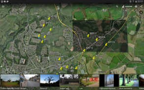
Design your survey forms, organize data on layers, work offline with mbtiles base-maps, access WMS services, use GPS tracking to capture your line and polygon features, record GNSS metadata and much more to discover.
The app is widely used by professionals around the world and can be easily adopted for different applications from agriculture and forestry to road construction, geology, land surveying and solar panel solutions. Personalized settings and flexibility makes this app fit for purpose tool which will enhance your surveying workflow.
App can be also used as a measurement tool to calculate areas or distances.
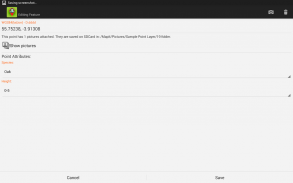
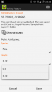
When saving location simply choose required attributes from predefined drop-down list, no need to type the same information over and over again. Import long list of attributes from text files and re-use them in number of projects. If necessary you can add pictures to each location as well.
If you are working in the field, gathering large amount of spatial data this app is designed for you.
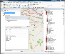
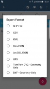
Speed up your workflow and make the data collection more efficient. Take advantage of survey layers and possibility to re-use same set of attributes for multiple surveys. Export your data to common GIS formats like Esri shapefiles, CSV, KML, geojson, DXF, GPX and post process your data using Desktop GIS software like qGIS.
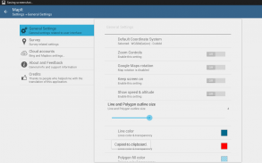
Support for number of predefined coordinate systems and customised EPSG codes if required.
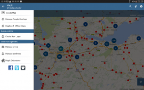
Mobile Data Collection Features:
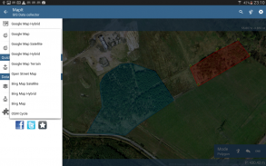
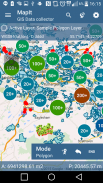
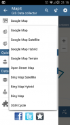
- Base maps: Popular online maps selections and offline mbtiles,
- Support for RTK corrected coordinates when external Bluetooth GPS / GNSS is connected,
- Support for WMS and GIS Server Tiled map services - load topographic and orthophoto maps, geological surveys, cadastral information and number of other services.
- Possibility to create and maintain sets of attributes - these are available as a drop down lists when new feature is being recorded, long lists of values can be imported from text files.
- Clusters for point map markers, efficient way of having large number of points on the map without performance issues,
- Currently 4 methods of collection are supported (GPS / GNSS location, map cursor location, tracking, point projection using angle and distance),
- Possibility to group your data into the survey layers - each survey layer may have a default set of attributes.
- Local SD card or remote export. At the moment shapefiles, KML, CSV, geojson, GPX and DXF export is supported,
- Direct export to Dropbox or FTP location
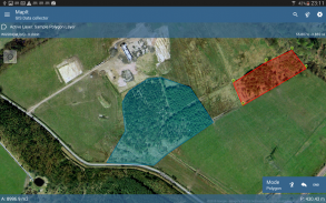
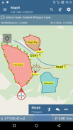
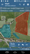
- Possibility to record multiple points, lines and polygons on one layer,
- When creating new polygon or line features measurement details like area or length are also available.
- GPS / GNSS and satellites status,
- Address, location search,
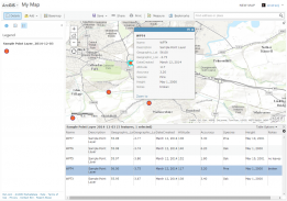
- Import point, line and polygon features into layer from CSV, KML, shapefile or geojson file,
- Backup management,
- Import/Export attributes from file and much more to discover...
Our users are successfully using Mapit in number of applications including:
- Environmental and woodland surveys,
- Forestry planning and woodland management,
- Agriculture and soil classifications and sampling,
- Road constructions,
- Land surveying,
- Solar panels applications,
- Roofing and fencing,
- Tree surveys,
- GPS and GNSS surveying,
- Site surveying
- Snow removal
Do not hesitate to contact us directly or using the contact form on our website.
Mapit เป็นเครื่องมือทำแผนที่แบบมืออาชีพแบบสแตนด์อโลนที่คุ้มค่าและได้รับการออกแบบมาเพื่อเพิ่มประสิทธิภาพในขณะที่คุณอยู่ที่นั่น
แอปรองรับรูปแบบไฟล์ทั่วไปสำหรับอินพุตและเอาต์พุตและสามารถทำงานกับจำนวนตัวรับ GNSS ภายนอกเพื่อให้คุณสามารถรับความแม่นยำระดับเซนติเมตรเมื่อคุณต้องการ
ออกแบบแบบสำรวจของคุณจัดการข้อมูลในเลเยอร์ทำงานออฟไลน์ด้วยแผนที่ฐาน mbtiles เข้าถึงบริการ WMS ใช้การติดตาม GPS เพื่อจับภาพคุณสมบัติเส้นและรูปหลายเหลี่ยมบันทึกข้อมูลเมตาของ GNSS และอีกมากมายที่จะค้นพบ
แอปพลิเคชั่นนี้ถูกใช้อย่างกว้างขวางโดยผู้เชี่ยวชาญทั่วโลกและสามารถนำไปใช้งานได้อย่างง่ายดายสำหรับการใช้งานที่หลากหลายตั้งแต่เกษตรกรรมและป่าไม้ไปจนถึงการก่อสร้างถนนธรณีวิทยาการสำรวจที่ดินและโซลูชั่นแผงโซล่าร์ การตั้งค่าส่วนบุคคลและความยืดหยุ่นทำให้แอพนี้เหมาะสำหรับเครื่องมือวัตถุประสงค์ที่จะช่วยปรับปรุงขั้นตอนการสำรวจของคุณ
แอปยังสามารถใช้เป็นเครื่องมือวัดในการคำนวณพื้นที่หรือระยะทาง
เมื่อบันทึกตำแหน่งเพียงเลือกแอตทริบิวต์ที่ต้องการจากรายการแบบหล่นลงที่กำหนดไว้ล่วงหน้าไม่จำเป็นต้องพิมพ์ข้อมูลเดิมซ้ำแล้วซ้ำอีก นำเข้ารายการคุณสมบัติแบบยาวจากไฟล์ข้อความและนำกลับมาใช้ใหม่ในจำนวนโครงการ หากจำเป็นคุณสามารถเพิ่มรูปภาพในแต่ละตำแหน่งได้เช่นกัน
หากคุณกำลังทำงานอยู่ในสนามรวบรวมข้อมูลเชิงพื้นที่จำนวนมากที่แอพนี้ออกแบบมาสำหรับคุณ
เร่งกระบวนการทำงานของคุณและทำให้การรวบรวมข้อมูลมีประสิทธิภาพมากขึ้น ใช้ประโยชน์จากเลเยอร์การสำรวจและความเป็นไปได้ที่จะใช้ชุดคุณลักษณะซ้ำสำหรับการสำรวจหลายชุด ส่งออกข้อมูลของคุณเป็นรูปแบบ GIS ทั่วไปเช่น Esri Shapefiles, CSV, KML, Geojson, DXF, GPX และโพสต์ประมวลผลข้อมูลของคุณโดยใช้ซอฟต์แวร์ Desktop GIS เช่น qGIS
รองรับจำนวนระบบพิกัดที่กำหนดไว้ล่วงหน้าและรหัส EPSG ที่กำหนดเองหากจำเป็น
คุณสมบัติการเก็บข้อมูลมือถือ:
- แผนที่ฐาน: การเลือกแผนที่ออนไลน์ยอดนิยมและออฟไลน์ mbtiles
- รองรับการแก้ไขพิกัด RTK เมื่อเชื่อมต่อ Bluetooth GPS / GNSS ภายนอกแล้ว
- รองรับบริการแผนที่แบบเรียงต่อกันของ WMS และ GIS Server - โหลดแผนที่ภูมิประเทศและแผนที่ออร์โธกราฟ, การสำรวจทางธรณีวิทยา, ข้อมูลเกี่ยวกับที่ดินและจำนวนบริการอื่น ๆ
- ความเป็นไปได้ในการสร้างและบำรุงรักษาชุดคุณลักษณะ - สิ่งเหล่านี้มีอยู่ในรายการแบบหล่นลงเมื่อมีการบันทึกคุณสมบัติใหม่รายการค่าที่มีความยาวสามารถนำเข้าได้จากไฟล์ข้อความ
- กลุ่มสำหรับตัวทำแผนที่จุดวิธีที่มีประสิทธิภาพของการมีจำนวนมากของจุดบนแผนที่โดยไม่มีปัญหาประสิทธิภาพ
- ปัจจุบันรองรับวิธีการเก็บรวบรวม 4 วิธี (ตำแหน่ง GPS / GNSS ตำแหน่งเคอร์เซอร์แผนที่การติดตามการฉายจุดโดยใช้มุมและระยะทาง)
- ความเป็นไปได้ที่จะจัดกลุ่มข้อมูลของคุณลงในเลเยอร์สำรวจ - แต่ละชั้นสำรวจอาจมีชุดแอตทริบิวต์เริ่มต้น
- การ์ด SD ในตัวเครื่องหรือส่งออกทางไกล รองรับการส่งออก shapefiles, KML, CSV, geojson, GPX และ DXF
- ส่งออกโดยตรงไปยังตำแหน่ง Dropbox หรือ FTP
- ความเป็นไปได้ในการบันทึกหลายจุดเส้นและรูปหลายเหลี่ยมในชั้นหนึ่ง
- เมื่อสร้างรูปหลายเหลี่ยมใหม่หรือรายละเอียดคุณสมบัติการวัดเส้นเช่นพื้นที่หรือความยาว
- สถานะ GPS / GNSS และดาวเทียม
- ที่อยู่การค้นหาตำแหน่ง
- คุณลักษณะการนำเข้าจุดเส้นและรูปหลายเหลี่ยมลงในเลเยอร์จากไฟล์ CSV, KML, รูปร่างไฟล์หรือ geojson
- การจัดการการสำรองข้อมูล
- นำเข้า / ส่งออกแอตทริบิวต์จากไฟล์และอีกมากมายที่จะค้นพบ ...
ผู้ใช้ของเราประสบความสำเร็จในการใช้ Mapit ในจำนวนแอปพลิเคชันรวมถึง:
- การสำรวจด้านสิ่งแวดล้อมและป่าไม้
- การวางแผนป่าไม้และการจัดการป่าไม้
- การจำแนกและการสุ่มตัวอย่างทางการเกษตรและดิน
- การก่อสร้างถนน
- การสำรวจที่ดิน
- การใช้งานแผงเซลล์แสงอาทิตย์
- หลังคาและรั้ว
- สำรวจต้นไม้
- การสำรวจ GPS และ GNSS
- การสำรวจไซต์
- กำจัดหิมะ
อย่าลังเลที่จะติดต่อเราโดยตรงหรือใช้แบบฟอร์มการติดต่อบนเว็บไซต์ของเรา
Mapit GIS - Map Data Collector & Land Surveys--เวอร์ชั่น7.8.0.0Core
(16-08-2021)

Mapit GIS - Map Data Collector & Land Surveys - ข้อมูล APK
เวอร์ชั่น APK: 7.8.0.0Coreแพ็คเกจ: com.osedok.gisdatacollectorเวอร์ชั่นล่าสุดของMapit GIS - Map Data Collector & Land Surveys
แอปในประเภทเดียวกัน
คุณอาจจะชอบ...


